Contents
- Executive summary
- 1. Introduction
- 2. The asset base
- 3. Planning advice and fieldwork statistics
- 4. Outcomes from previous planning advice
- 5. An overview of the patterns of archaeological fieldwork in 2023
- 6. Public engagement
- 7. Developing the archaeological research agenda
- 8. Other available monitoring data on the historic environment
- Glossary and definitions
Executive summary
The following report provides an overview of the impact of development on archaeological assets in the Oxford Local Authority Area in 2023.
This year saw a reduction in the number of large scale or intensive excavations with some notable consented schemes on pause, perhaps reflecting the situation in the wider economy. Another feature of the year was the impact of higher-than-average rainfall which created challenges for the excavation of certain sites, for example the Gibbs Crescent excavation site, and that also resulted in management issues for the ridge and furrow earthworks in South Park where public events are hosted.
A distinctive feature of the year was the rare opportunity to investigate the periphery of a Roman pottery manufacturing area at the former Conservative Club site on Between Towns Road. In addition to the publication of the results of this site further outreach material is planned related to Oxford’s important Roman pottery industry, including the first artist’s reconstruction illustration of an Oxford pottery manufacturing compound. Elsewhere a number of small but significant discoveries were made as a result of evaluation and watching brief work. These discoveries are connected to the relevant Oxford Archaeological Research Agenda questions at the end of the document.
1. Introduction
The National Planning Policy Framework requires that local planning authorities should make information about the significance of the historic environment, gathered as part the development management process, publicly accessible. The Oxford Archaeological Plan (2018) established the objective of producing an annual monitoring statement for archaeological heritage assets and this is the eleventh such report. The aim being to capture data about the patterns of development impacts across the years and also monitor the effectiveness of heritage management processes.
The following report provides a short overview of the scope and impact of development led archaeology in Oxford in 2023. It records the number of planning applications submitted over the calendar year and the number assessed to have likely archaeological implications. It records the types of archaeological fieldwork undertaken and summarises how development and archaeological mitigation have impacted on known archaeological heritage assets. Furthermore, it relates the year’s archaeological discoveries to an evolving research agenda to show how our knowledge and understanding of Oxford and its people is developing and expanding over time. The annual statement also provides a basis for monitoring the on-going cumulative impact of both development and asset management on the city’s archaeological resource.
2. The asset base
The designated assets within the Oxford City local authority area comprise:
- Over 1,500 listed buildings (this number relates to the number of buildings rather than designations as these can encompass multiple buildings. At the end of 2023 the National Heritage List recorded 1186 listed building designations for Oxford.
- 12% grade I listed buildings (the national average is 2%)
- 8% grade II* listed buildings (the national average is 4%)
- 18 Conservation Areas – representing 20% of the city area
- 10 Scheduled Ancient Monuments (NB The National Heritage List now records ten monuments rather than the previously stated 12 because the Bridge West of Godstow Abbey (County No 173) and the extension to Port Meadow (County No 120003) are amalgamated with Godstow Abbey (County Number 35542) and Port Meadow (County Number 143) respectively.
- 15 Registered Parks and Gardens
In addition to these designated assets further archaeological monuments are recorded on archaeological databases covering the city. The monument database includes extant and documented monuments (i.e. those which may no longer survive).
At present two complementary archaeological data sets are maintained for Oxford: The Urban Archaeological Database (UAD) which covers the historic core of Oxford and the Oxford Historic Environment Record (HER) which covers the area outside the UAD. These two sets of data are both now maintained by the City Council and have been recently combined into the City of Oxford Urban Historic Environment Record (COUHER).
The combined monument database (which includes a number of duplicate records that need revision) totals 3393 records (Oxford District Search). This number has increased over the year due to work undertaken on the transfer of records from the National Record for the Historic Environment onto the Oxford HER.
3. Planning advice and fieldwork statistics
The information and tables below provide data about the number of applications assessed and commented on by the City Council Archaeologist and the number of archaeological recording events undertaken by archaeological contractors in Oxford in 2022. Additional data is provided on the number of Scheduled Monument Consent notices issued by Historic England over the course of the year.
- Number of applications assessed for heritage interest (excluding renewals and amended schemes): 1,386 (including full, outline, pre-applications, major applications, listed building applications)
- Number of applications with archaeological implications in 2023: 40
- Number of applications with archaeological implications as a % of planning applications:
- 2019 - 3.6%
- 2020 - 2.6%
- 2021 - 3.4%
- 2022 - 3.1%
- 2023 - 2.8%
| 2018 | 2019 | 2020 | 2021 | 2022 | 2023 | |
|---|---|---|---|---|---|---|
| Evaluation trenching | 8 | 13 | 9 | 11 | 8 | 10 |
|
Trial trenching (keyhole investigation secured through a planning condition, usually because of pre-existing site constraints) |
8 |
7 |
2 |
5 |
3 |
3 |
|
Archaeological excavations |
6 |
9 |
2 |
10 |
7 |
3 |
|
Archaeological watching briefs (observation of ground works by a qualified archaeologist) |
19 |
21 |
23 |
17 |
15 |
12 |
|
Historic building recording |
11 |
9 |
9 |
5 |
4 |
8 |
|
Geophysical survey |
1 |
4 |
8 |
3 |
3 |
1 |
|
Salvage record (reactive recording of an asset either because of non-compliance with a condition or because activity is outside planning control) |
1 |
0 |
2 |
0 |
0 |
2 |
|
2018 |
2019 |
2020 |
2021 |
2022 |
2023 |
|
|---|---|---|---|---|---|---|
|
Number of cases requiring Scheduled Monument Consent |
0 |
5 |
1 |
1 |
1 |
1 |
|
Number of Scheduled Monument consents for complete or partial loss of fabric or character requiring mitigation of damage |
0 |
1 |
0 |
0 |
0 |
0 |
|
Number of Scheduled Monument consents for minor works without significant implications |
0 |
4 |
1 |
1 |
1 |
0 |
|
Number of Scheduled Monument consents for repair and restoration of monuments |
0 |
1 |
0 |
1 |
0 |
1 |
4. Outcomes from previous planning advice
The tables below provide data on the outcomes of development on archaeological assets and an assessment of impact based on definitions provided by the National Planning Policy Framework.
|
2018 |
2019 |
2020 |
2021 |
2022 |
2023 |
|
|---|---|---|---|---|---|---|
|
Number of significant breaches of planning condition or damage cases recorded over the year |
2 |
0 |
0 |
1 |
0 |
1 |
|
Non-compliance with an archaeological condition with unknown impact on asset/s |
2 |
0 |
0 |
0 |
0 |
2 |
|
Non-compliance with archaeological condition with subsequent mitigation undertaken |
0 |
0 |
2 |
1 |
0 |
1 |
|
Number of appeals allowed where archaeological policies are cited as a reason for refusal |
0 |
0 |
0 |
0 |
0 |
0 |
|
Number of developments in 2022 within the City Centre Archaeological Area (defined in the Local Plan) that required a full excavation more than 25m2 |
3 |
4 |
2 |
3 |
2 |
1 |
|
Number of developments in 2022 outside the City Centre Archaeological Area (defined in the Local Plan) that required an excavation more than 100m2 |
0 |
4 |
0 |
2 |
0 |
0 |
|
Number of major archaeological excavations awaiting publication more than two years after the completion of fieldwork |
13 |
13 |
9 |
8 |
12 |
18 |
|
Number of fieldwork events that did not encounter archaeologically significant assets (these may include sites where archaeological monitoring has been required to ensure that consented development does not impact on significant remains) |
7 |
11 |
14 |
15 |
6 |
7 |
|
Number of cases in City Centre Archaeological Area (defined in the Local Plan) where design was agreed, or design changes made, to avoid or achieve significant reduction in harm to or achieve significant preservation in situ of archaeological assets |
2 |
2 |
3 |
3 |
2 |
2 |
| Number of cases outside City Centre Archaeological Area (defined in the Local Plan) where design was agreed, or design changes made, to avoid or achieve significant reduction in harm/significant preservation in situ to archaeological assets | 1 | 1 | 0 | 0 | 0 | 1 |
Summary of archaeological assets impacted by development in 2023
Gibb’s Crescent
Asset type: Augustinian Abbey
- Less than substantial loss of asset without mitigation
- Less than substantial loss of asset with mitigation
Notes: Fishponds, structures and the precinct wall of the Abbey recorded. Damage caused by main contractor (not yet fully quantified and reported).
Between Town’s Road Conservative Club
Asset type: Roman pottery manufacturing compound
- Less than substantial loss of asset with mitigation
Notes: Roman enclosures, ditches, pits, clay dump and pottery waster dumps.
St Giles St John's walled garden
Asset type: Post medieval forward garden enclosure
- Further characterisation of asset with limited intervention
Notes: Modern soil only (plus fragments of oyster shell and Victorian pottery).
No 12 High Street All Souls properties
Asset type: 16th and 17th century town house
- Further characterisation of asset with limited intervention
Notes: Roof more closely dated to 16th century and building recording undertaken.
Nos 11-13 High Street High Street All Souls properties
Asset type: Late Saxon and medieval buildings
- Further characterisation of asset with limited intervention
Notes: Multiple structures conjectured from small test pit samples
Christ Church Deanery
Asset type: 16th century college
- Further characterisation of asset with limited intervention
- New asset identified with limited intervention
Notes: New 16th century tower fragment identified and dated demonstrating that part of the Deanery is older than previously thought.
South of East Gate
Asset type: Medieval city defences
- Further characterisation of asset with limited intervention
- New asset identified with limited intervention
Notes: Borehole survey confirms presence of city ditch south of Eastgate and part of the medieval surveyed for the first time producing phased section drawings.
Pusey Lane
Asset type: Prehistoric features (by character only)
- Further characterisation of asset with limited intervention
Notes: Fragments of likely prehistoric features (perhaps a round barrow/s) identified during small scale test pitting.
No 2 Charlbury Road
Asset type: Early 20th residential building (Grade II)
- Further characterisation of asset with limited intervention
Notes: Historic building record undertaken
Railway Station
Asset type: Victorian railway infrastructure
- Further characterisation of asset with limited intervention
Notes: GWR Railings and old type of track recorded Barracks Road Car Park and inverted foundation of Railway Bridge exposed.
Magdalen College OKB
Asset type: Hospital of St John the Baptist
- Further characterisation of asset with limited intervention
Notes: Structural features and yard surface with post holes recorded.
Trinity Garden
Asset type: Medieval tenements
- Further characterisation of asset with limited intervention
Notes: Likely medieval tenement remains facing onto South Parks Road recorded.
Trinity Garden
Asset type: 18th century formal garden
- Further characterisation of asset with limited intervention
Notes: Garden paths and features recorded.
University Parks Badger Set
Asset type: Iron Age settlement remains.
- Further characterisation of asset with limited intervention
Notes: Iron Age pits recorded.
No 117 High Street (salvage)
Asset type: Ealy modern building (c1812)
- Further characterisation of asset with limited intervention
Notes: Early modern features recorded.
No 131 High Street
Asset type: 18th c building
- Further characterisation of asset with limited intervention
Notes: Exposure and repair of the timber frame of No 131 High Street. The building dates from the mid-1830s.
Pembroke Street
Asset type: Late Saxon domestic activity
- Further characterisation of asset with limited intervention
Notes: Late Saxon features recorded for the first time of Pembroke Street
Warnock Place
Asset type: Post medieval Tanning site
- Further characterisation of asset with limited intervention
Notes: Tanning waste identified
Ruin at Osney Marina
Asset type: Victorian ruin with likely medieval elements related to Oseney Abbey
Notes: Basic record of the structure produced by Oxfordshire Building Record
Totals
- Loss of asset without mitigation - 0
- Loss of asset with mitigation - 0
- Substantial loss of asset without mitigation - 0
- Substantial loss of asset with mitigation - 0
- Less than substantial loss of asset without mitigation - 1
- Less than substantial loss of asset with mitigation - 2
- Further characterisation of asset with limited intervention - 17
- New asset identified with limited intervention - 2
5. An overview of the patterns of archaeological fieldwork in 2023
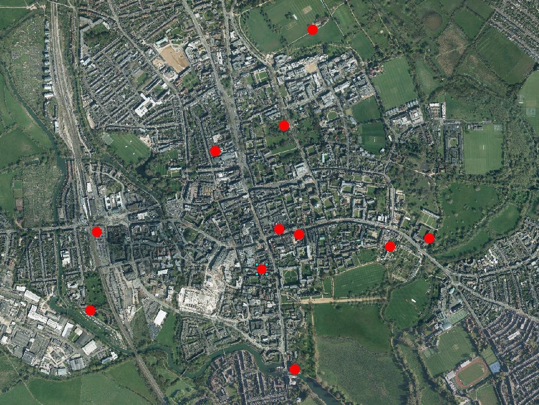
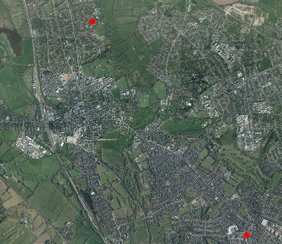
The sites assessed in section 4 are mapped below in order to show the broad pattern of investigation.
Current archaeological planning policy and the preservation of archaeological remains
The Oxford Local Plan Policy DH4 is reproduced below, it introduces a new emphasis on assessment of cumulative impacts on specific heritage asset types and community involvement (where feasible).
Within the City Centre Archaeological Area, on allocated sites where identified, or elsewhere where archaeological deposits and features are suspected to be present (including upstanding remains), applications should include sufficient information to define the character, significance and extent of such deposits so far as reasonably practical. This information should generally include:
- a Heritage Assessment that includes a description of the impacted archaeological deposit or feature (including where relevant its setting), an assessment of its significance and the impact of the proposed development on its significance, in all cases using a proportionate level of detail that is sufficient to understand the potential impact of the proposal. The Statement should reference appropriate records (including the information held on the Oxford Historic Environment Record); and
- If appropriate, a full archaeological desk-based assessment and the results of evaluation by fieldwork (produced by an appropriately qualified contractor. Pre- application discussion is encouraged to establish requirements). In the City Centre Archaeological Area where significant archaeological asset types can be shown to be subject to cumulative impact from development, the desk-based assessment should contain appropriate contextual assessment of this impact.
Development proposals that affect archaeological features and deposits will be supported where they are designed to enhance or to better reveal the significance of the asset and will help secure a sustainable future for it.
Proposals which would or may affect archaeological remains or features which are designated as heritage assets will be considered against the policy approach as set out in policy DH4 DH3 above.
Archaeological remains or features which are equivalent in terms of their significance as to a scheduled monument are given the same policy protection as designated heritage assets. Proposals which affect the significance of such assets will be considered against the policy test for designated heritage assets set out in policy DH4 above.
Subject to the above, proposals that will lead to harm to the significance of non-designed archaeological remains or features will be resisted unless a clear and convincing justification through public benefit can be demonstrated to outweigh that harm, having regard to the significance of the remains or feature and the extent of harm.
Where harm to an archaeological asset has been convincingly justified and is unavoidable, mitigation should be agreed with Oxford City Council and should be proportionate to the significance of the asset and impact. The aim of mitigation should be where possible to preserve archaeological remains in situ, to promote public enjoyment of heritage and to record and advance knowledge. Appropriate provision should be made for investigation, recording, analysis, publication, archive deposition and community involvement.
Overview of 2023
This year saw a reduction in the number of large scale or intensive excavations with some notable consented schemes on pause, perhaps reflecting the situation in the wider economy. Another feature of the year was the impact of higher-than-average rainfall which created challenges for the excavation of certain sites, for example the Gibbs Crescent excavation site, and that also resulted in management issues for the ridge and furrow earthworks in South Park where public events are hosted. The Gibbs Crescent site involved an unfortunate episode involving damage to buried Abbey remains by the main contractor. As the main contractor subsequently declared bankruptcy and was removed from the site no further action was taken other than to ensure the remaining work was undertaken appropriately.
A distinctive feature of the year was the rare opportunity to investigate the periphery of a Roman pottery manufacturing area at the former Conservative Club site on Between Towns Road. In addition to the publication of the results of this site further outreach material is planned related to Oxford’s important Roman pottery industry, including the first artist’s reconstruction illustration of an Oxford pottery manufacturing compound.
Another important piece of work undertaken this year was undertaken as part of predetermination process that is not yet in the public domain however, we can report that the work involved the likely identification of the medieval city ditch south of the East Gate (which had not previously been proven). Furthermore, a localized collapse of a section of the Scheduled City Wall at Merton College was he subject of careful repair works supervised by Historic England.
Alongside the usual outreach activities undertaken by the City Council Archaeologist the year was notable for the online release of a series of interviews constituting an oral history of the Boswells department store as a response to its conversion to the Store Hotel.
Elsewhere a number of small but significant discoveries were made as a result of evaluation and watching brief work. These discoveries are connected to the relevant Oxford Archaeological Research Agenda questions at the end of the document.
6. Public engagement with archaeological heritage
The Oxford Archaeological Action Plan 2013-2018 sets out the aspiration of the Urban Design and Heritage Team to maintain a programme of public outreach including talks, walks and media engagement. Below a selection of archaeological outreach work in 2023 are highlighted:
- Outreach activities of The City Council Archaeologist (CCA) included talks on recent archaeological work in Oxford for the Festival of Archaeology (Organised by Oxford Archaeological Trust and the annual OXPAST festival. A further talk was given at a day conference on the ‘Archaeology of Oxford’ at Cherwell School, organised by the South Midlands Group of the Council for British Archaeology.
- A previous conference talk by the City Council Archaeologist on Oxford’s Civil War Defences has been published in a conference proceedings volume.
- An outreach leaflet was produced by Museum of London Archaeology detailing the results of the excavations at New College School in 2020. The leaflets were distributed to the school, New College and the Museum of Oxford. A Roman Pottery Industry leaflet was commissioned for release in 2024.
- The redevelopment of Rhodes House is now complete and the Royalist Civil War rampart (forming part of the inner line of the northern defences) is now more prominent in the public realm and celebrated with a plaque at Rhodes House, South Parks Road, Oxford.
- As part of the package of recording undertaken in relation to the conversion of the Boswells department store to a hotel Chronicles Storytelling compiled a series of over 50 interviews with staff and customers capturing the social history of the well-loved Oxford store. You can listen to the interviews on Vimeo.
The top ten Oxford archaeological digs/events of the year were tweeted at Christmas 2023 (5,701 impressions).
Further information on the results of archaeological fieldwork in the City can be found in the regularly produced Oxford City and County Archaeological Forum reports which are posted onto the Archaeology page of the council website.
7. Developing an archaeological research agenda for Oxford
In 2012 the City Council completed an English Heritage funded project to produce a synthesis of the available archaeological information for Oxford and set out a research agenda to inform future investigations. These reports formed part of the Oxford Archaeological Plan.
The archaeological investigations undertaken in 2023 have produced significant new data relevant to the 2012 research agenda and the table below seeks to illustrate how the various investigations fit into the agenda. It should be noted that many of the larger sites investigated in 2023 have not yet been subject to a detailed post-excavation study and therefore the full results are not yet known. The statements below are therefore provisional.
Pusey Lane
Notes: Orange loam fills of feature suggest the location of another Late Neolithic - Early Bronze Age barrow on St John Street (speculative).
Research Question:
2.8.9. Early Bronze Age barrows are proving to be more complex than previously thought in terms of their content, forms and the burial practices and other ritual activities associated with them, such as processions. Some of this evidence is found in the upper deposits of the barrows or beyond their physical extents and can be easily damaged if not recognised. Further analysis of their chronology and function is needed.
Period: Neolithic to Bronze Age
University Parks (Badger Fencing)
Notes: Iron Age pits (including evidence of a dog skeleton (Collie like in type). Providing further information on the character of Iron Age settlement in the University Parks Area.
Research Question:
3.4. 10. How well settled was the landscape during the LIA to Roman transition? Did existing settlement patterns or boundaries have an effect on Roman rural landscape or the nascent 1st century manufacturing landscape (e.g. at the Churchill Hospital site)?
Period: Iron Age
Conservative Club, Between Towns Road
Notes: Edge of pottery manufacturing compound (adjacent to site of ‘Vossulus’ literate potter’s stamp evidence). Evidence for waster dumps, illiterate stamps, clay dump and boundaries help further establish the layout of this important pottery manufacturing area.
Research Question:
4.6.1. What is the full character and extent of manufacturing infrastructure within the LAA? Can well preserved kiln sites be identified and conserved?
4.6.3. What is the relationship between kilns, workshops, settlements, quarries, water sources and woodland?
4.6.11. How do pottery production areas compare? Is there further evidence for formal layouts (like at Lower Farm), or for clean and well ordered sites (i.e. Churchill Hospital), sites with mixed quality production (quantities of wasters etc.), or less well ordered sites?
Period: Roman
Nos 11-13 High Street
Notes: Evidence for Middle (?) and Late Saxon pits and cellar pits. Small samples but demonstrate the potential for this central market area to reveal more information about the emergence of Oxford.
Research Question:
5.5.5. Can the archaeological record tell us anything about the period of Mercian control in the Oxford area?
5.5.6. Aside from the area next to the Thames crossing at St Aldates, a number of other potentially significant Middle-Late Saxon activity centres have been suggested in the LAA (e.g. Royal Estate at Headington, a trading wic at Eastwyke Farm, a monastery at Binsey, the recovery of Ipswich ware from two Beaumont Street sites but not elsewhere in the town). The further investigation of these sites/areas is therefore of considerable interest.
Period: Saxon
Nos 21-24 Pembroke Street
Notes: Rectangular and amorphous features of Late Saxon or medieval date cut into the gravel below. First modern identification of domestic Late Saxon activity in Pembroke Street.
Research Question:
5.5.17. The evolving character and distribution of Late Saxon cellar pits off the major commercial frontages is of interest in plotting the urbanisation and commercial development of the settlement. Can we learn more about plot/structure density and form?
5.5.18. Can the study of pit assemblages help further establish domestic/agricultural/commercial/manufacturing character zones within the settlement?
5.5.19. Can we learn more about the laying out and development of early property division within the town? Can the character and extent of pre-conquest estates and properties held in within the burh be identified?
Period: Saxon
Gibbs Crescent, Oseney Abbey
Notes: These works identified the line of the abbey precinct wall and an area within the wall comprised of surfaces and walls representing buildings and working areas that seem to have been abandoned in the 14th century and replaced by fishponds, presumably because the low lying land next to the Thames was considered too liable to flooding.
Research Question:
7.7.1. The plan-form of a number of friaries and abbeys have been archaeologically investigated; can we learn more about the daily life within religious institutions – the diet and health, daily routine?
7.7.3. There is good potential for the sites of religious houses located on reclaimed land in the floodplain to preserve environmental evidence for diet, land-use and water and fish management.
7.7.5. Can the material culture and architecture of the friaries and abbeys tell us more about the relative wealth and functions of rival orders?
Period: Medieval
Ruin, Osney Marina, Oseney Abbey
Notes: A four-sided ruin with one side showing signs of medieval construction. The structure is of additional interest because of the extensive use of water washed limestone cobbles rather than quarried stone.
Research Question:
7.7.1. The plan-form of a number of friaries and abbeys have been archaeologically investigated; can we learn more about the daily life within religious institutions – the diet and health, daily routine?
Period: Medieval
Trinity College Garden
Notes: Evidence of medieval activity fronting onto South Parks Road which fits with emerging evidence for an ‘artisan spine’ of trades associated with the University concentrating in tenements along Schools Street and Catte Street and extending along South Parks Road to the north in the 13th - early 14th century.
Research Question:
7.5.1. The archaeology of medieval Oxford has exceptional potential to clarify apparent patterns of economic expansion of the town in the 12th-early 13th century and the subsequent contraction and decline in the later 13th-15th centuries. To what extent can this pattern be refined with relation to geographical areas, trades and specific communities and institutions? Can the assumed drivers of wealth creation in the wool and cloth trades be archaeologically identified? Can the subsequent apparent shift to service industries supplying the collegiate market be likewise identified? Are these proposed patterns of change reflected in the hinterland villages?
Period: Medieval
Nos 11-13 High Street, All Souls College
Notes: Evidence for medieval structures including extant fabric in party walls likely to predate the post medieval structure above.
Research Question:
7.6.5. Can we further establish the character and ranking of town houses (Munby 2008)? What can patterns of rebuilding and growth tell us about patterns of changing wealth, agricultural change, new requirements, comfort, privacy etc (Munby 2008)?
Period: Medieval
Magdalen College Old Kitchen Building
Notes: Walls, yard and surfaces relating to the Hospital of St John the Baptist challenging the previously projected layout on the medieval hospital.
Research Question:
7.5.9. The Hospitals of St John and St Bartlemas are of great interest for studying the development of such institutions and their relationship with urban populations.
Period: Medieval
South of East Town Ditch
Notes: Line of medieval town ditch confirmed south of the East Gate by borehole transect (to reasonable level of confidence, no supporting dating). Section of town wall subject to phasing survey.
Research Question:
7.8.2. How was the town wall managed in terms of intra- and extra-mural space, repairs and posterns? When was the Saxon rampart slighted and removed?
7.8.3. Can we further identify patterns of rebuilding and repair in the extant and buried fabric of the medieval town wall and its bastions?
7.8.5. There is a pressing need for a comprehensive drawn survey of the extant walls and synthesis of the available information.
7.8.6. Can the line of the medieval city ditch be confirmed south of Eastgate? What are the implications if it is not present here?
Period: Medieval
St Giles, St John's College walled forecourt
Notes: Test pitting characterised the nature of the soil build up over this unique survival of the post-medieval forecourt.
Research Question:
8.12.1 Can the line, phasing and character of the Royalist defences and Parliamentarian siege works be further established? Earthwork surveys of the extant defences would be of great value. Can geophysics tell us more about the Parliamentarian siege works?
Period: Post-medieval
No 12 High Street, All Souls College
Notes: Post-medieval house. Roof timbers dated to 16th century by dendrochronology.
Research Question:
8.8.1 1 A greater emphasis on the investigation and recording of post medieval structures within the district is required from domestic to civic to industrial structures because of the greater pressures on these structures. There is an increasing need to document in detail nationally important listed buildings as well as those structures of a more local interest.
Period: Post-medieval
Christ Church Deanery
Notes: The works revealed an unexpected void and curving wall of well-cut ashlar that encased the remains of a previously unknown Tudor polygonal tower. The working theory is that the northern end of the 16th century eastern range of Tom Quad extended further north than previously thought and was finished off with two small polygonal towers before Tom Quad was finally completed in the 17th century with the addition of the Deanery and northern range.
Research Question:
8.9. Detailed and comprehensive building surveys of college structures, including phased plans identifying extent of medieval and post medieval elements, are required. Inclusion of these surveys into a holistic conservation management plan enhancing the college’s past would be highly desirable as would conservation plans for the Registered Parks and Gardens where not in place.
Period: Post-medieval
Oxford Railway Station Bridge and Car Park
Notes: The works revealed an unforeseen inverted brick arch under the Botley Road rail bridge, a stone lined conduit near Oseney Lane, original GWR spearhead shaped railings at Becket Street car park and a 19th century Broad Gauge Barlow rail re-used as gate post at the Botley Rd and Beckett St car park junction.
Research Question:
9.5.5. Can we further understand the character and extent of railway infrastructure from the second half of the 19th century?
Period: Early Modern
Warnock Place
Notes: Evidence for a tanning pit was recorded
Research Question:
9.5.3. Sites related to specialised local production may warrant targeted recording (e.g. printing, brewing, tanneries, paper and card board production, boat making).
Period: Early Modern
117 High Street (salvage)
Notes: Structure subject to survey revealing original detail.
Research Question:
9.4.5. Further work to identify and catalogue examples of the early use of building materials, construction techniques or innovative design may be fruitful. How did the increased availability of building materials affect local building techniques and styles?
9.4.10. Can we locate and quantify further examples of Modern era domestic housing particularly pre-1945 local authority housing examples, and identify exemplars that might warrant recording in the event of development? Where do they survive and how have they fared in the modern townscape?
Period: Early Modern
No 131 High Street
Notes: Late timber framing (c1830s) exposed and was well-built, with joists integrated into the structure and primary iron ties reinforcing the corners and roof trusses. Tall and narrow softwood was used and numerous Baltic timber marks were observed.
Research Question:
9.4.5. Further work to identify and catalogue examples of the early use of building materials, construction techniques or innovative design may be fruitful. How did the increased availability of building materials affect local building techniques and styles?
9.4.10. Can we locate and quantify further examples of Modern era domestic housing particularly pre-1945 local authority housing examples, and identify exemplars that might warrant recording in the event of development? Where do they survive and how have they fared in the modern townscape?
Period: Early Modern
No 2 Charlbury Road
Notes: Early 20th century house subject to recording. Exemplar of its kind.
Research Question:
9.4.5. Further work to identify and catalogue examples of the early use of building materials, construction techniques or innovative design may be fruitful. How did the increased availability of building materials affect local building techniques and styles?
9.4.10. Can we locate and quantify further examples of Modern era domestic housing particularly pre-1945 local authority housing examples, and identify exemplars that might warrant recording in the event of development? Where do they survive and how have they fared in the modern townscape?
Period: Early Modern
8. Other available monitoring data on the historic environment of Oxford
Additional monitoring indicators on the historic environment can be found in the Local Development Framework Annual Monitoring Report.
This records the following:
- The number of heritage assets at risk in the Local Authority Area as assessed by Historic England.
Glossary and definitions
Archaeological interest: There will be archaeological interest in a heritage asset if it holds, or potentially may hold, evidence of past human activity worthy of expert investigation at some point. Heritage assets with archaeological interest are the primary source of evidence about the substance and evolution of places, and of the people and cultures that made them.*
Conservation (for heritage policy): The process of maintaining and managing change to a heritage asset in a way that sustains and, where appropriate, enhances its significance.
Evaluation: Archaeological trench or trenches excavated before the determination of a planning application in order to characterise and understand any archaeological remains that may be present rather than fully record them.
Evidential value: Value deriving from the potential of a place to yield evidence about past human activity.
Geophysical survey: Non-intrusive ground-based physical sensing techniques used for archaeological imaging or mapping.
Heritage asset: A building, monument, site, place, area or landscape identified as having a degree of Significance meriting consideration in planning decisions, because of its heritage interest. Heritage asset includes designated heritage assets and assets identified by the local planning authority (including through the local heritage asset register).
Historic environment: All aspects of the environment resulting from the interaction between people and places through time, including all surviving physical remains of past human activity, whether visible, buried or submerged, and landscaped and planted or managed flora.*
Historic environment record: An information service that seeks to provide access to comprehensive and dynamic resources relating to the historic environment of a defined geographic area for public benefit and use.*
National Planning Policy Framework: The National Planning Policy Framework (NPPF) sets out the Government’s planning policies for England and how these are expected to be applied. The NPPF states that Local planning authorities should recognise that heritage assets are an irreplaceable resource and conserve them in a manner appropriate to their significance.
Mitigation: An archaeological mitigation strategy is a statement of proposals for reducing the overall effect of a development on archaeological remains within the site. The strategy will normally consist of one or more of the following: Preservation in-situ, modifications to the development design proposals and archaeological recording (excavation, watching brief etc.).
Research agenda: Research questions that we would like to answer by investigating archaeological remains.
Resource assessment: A summary of the information produced by previous archaeological fieldwork.
Significance (for heritage policy): The value of a heritage asset to this and future generations because of its heritage interest. That interest may be archaeological, architectural, artistic or historic. Significance derives not only from a heritage asset’s physical presence, but also from its setting.
Substantial harm: The NPPF practice guidance states that what matters in assessing if a proposal causes substantial harm is the impact on the significance of the asset. Significance derives not only from a heritage asset’s physical presence, but also from its setting. While the impact of total destruction is obvious, partial destruction is likely to have a considerable impact but, depending on the circumstances, it may still be less than substantial harm or conceivably not harmful at all. Similarly, works that are moderate or minor in scale are likely to cause less than substantial harm or no harm at all. However, even minor works have the potential to cause substantial harm i.e. the scale of the works is not necessarily determinative of whether any harm caused is substantial or less than substantial. A key factor in determining whether the works constitute substantial (i.e. serious) harm is if the adverse impact goes to the heart of why the place is worthy of designation – why it is important enough to justify special protection.


