- Address
- New Marston Meadows
- Area
- Marston
- Comments
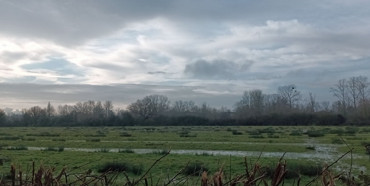
- Riverside meadows and meads on the eastern side of the River Cherwell between Marston Ferry Road and Mesopotamia, including fields containing evidence of ridge and furrow cultivation from the Middle Ages.
- Type of nomination
- Public nomination
- Nomination details
-
Location
Please note that site boundaries for nominations are approximate.
Open the location of the proposed New Marston Meadows area in Google Maps.
New Marston Meadows is the name given to the riverside meadows and meads on the eastern side of the River Cherwell between Marston Ferry Road to the north and the area alongside / east of Mesopotamia to the south. ‘New Marston Meadows’ is the name given to a Site of Special Scientific Interest in this area, but the community supports the application to identify a wider area that includes many adjacent meadows including the Oxford Wildlife Site (SLINC) adjacent to Park Farm. The area we wish to record as New Marston Meadows specifically includes the fields that continue to show evidence of ridge and furrow cultivation from the Middle Ages. This latter feature provides an important criterion for treating the whole riverside field system in New Marston as a historic entity and an important heritage asset for the city of Oxford.
The area is crossed by a network of officially designated footpaths and links via the riverside path to the riverside valley fields higher up the Cherwell valley northwards alongside Old Marston village. The still visible historic palimpsest (of ridge and furrow remnants) is a key landscape feature which defines a coherent and historic meadow / field system within the lower River Cherwell valley as a whole. The analysis of the lower Cherwell Valley by Land Use Consultants for Oxford City Council (A Character Assessment of Oxford in its Landscape Setting, 2002) is one major evidential support for the current application for inclusion of New Marston Meadows in the OHAR.
The 2002 analysis refers to New Marston Meadows and Park Farm Meadows separately but shows how jointly and in combination they define the landscape character of the lower Cherwell valley more widely to provide a landscape setting that includes “…a network of flood plain grasslands…of national ecological significance…of a type that is now rare in both Britain and Europe, and a BAP priority area” (page ref 259).
What is it?
- landscape (an area defined by visual features or character, e.g. a city centre, village, suburb or field system)
Why is it interesting?
- Historic interest – a well documented association with a person, event, episode of history, or local industry
New Marston Meadows are interesting for their historic association / palimpsest showing remnants of medieval horticulture / agriculture. The area we now define as New Marston Meadows represent a largely untouched example of riverside flowery meads and pastures linked back several hundred years. The ridge and furrow pattern seen in most of the meadows is indicative of that history and is a key to their ecology / biodiversity. The diverse flora and fauna has been preserved due to relatively unchanged management of the meadows since medieval times. These are lot [lotte] meadows where the meads closest to the River Cherwell were / subject to river flooding in the winter have never been suitable for ploughing. These meads were divided into lots and allocated annually to local farmers for haytaking. Currently, these fields remain largely untouched or if hay is taken this happened well after midsummer when early wildflowers have dropped seed. Aftermath (autumn) cattle grazing takes place from July onwards which has the effect of keeping down intrusive plants (such as coarse grass, blackthorn and bramble scrub) and helps ensure their continuation as ‘flowery meads’.
The SSSI in the lower River Cherwell valley is known specifically for the rare association between Meadow Foxtail and Great Burnet (Alison W. McDonald, The history and ecology of North and South Meads, Wolfson College Oxford paper, n.d. and Judy Webb, Report for the Rare Plants Group of the Ashmolean Natural History Society of Oxfordshire / New Marston Wildlife Group, 2011 - see the New Marston Meadows page on the the Judith Webb website.
New Marston Meadows SSSI (designated 1993) contains 44.42 ha of fields that were designated either as good examples of lowland neutral grassland, NVC (National Vegetation Classification) community MG4, Meadow Foxtail – Great Burnet (Alopecurus pratensis-Sanguisorba offininalis) flood meadow or as variants of a valuable, more swampy, meadow or grazed-meadow type and one on slightly higher ground is a drier community most similar to NVC community MG5, Crested Dog’s-tail – Knapweed (Cynosurus cristatus – Centaurea nigra)
11 plants on the draft Rare Plants Register (RPR) for Oxfordshire are found in the meadows adjacent to the Cherwell River within the New Marston Meadows SSSI boundaries. There are a further three species on the draft RPR in meadows outside the SSSI but within a Local Wildlife Site.
The latter comment by Dr. Judy Webb makes reference to a ‘Local Wildlife Site’ (designated in the Local Plan 2036) adjacent to Park Farm.
The Meadows are also of interest for wildlife / fauna with interesting birds (e.g. little owls, herons. kingfisher etc.), moths and butterflies and mammals (e.g. deer, badgers etc.).
Wildflower meadows were once a common sight in lowland England but it is now said that 97% of these have disappeared over the last century as a result of intensification in agriculture and urban expansion. Floodplain meads have suffered most in terms of overall wildflower meadows loss, according to the Berkshire, Buckinghamshire and Oxfordshire Wildlife Trust (BBOWT) with an estimate that only 1500 ha. are now left in England.
Why is it locally valued?
- Illustration: It illustrates an aspect of the area’s past that makes an important contribution to its identity or character - 1
- Evidence: It is an important resource for understanding and learning about the area’s history - 2
- Aesthetics: It makes an important contribution to the positive look of the area either by design or fortuitously - 3
- Communal: It is important to the identity, cohesion, spiritual life or memory of all or part of the community - 4
Apart from the historic landscape and ecological value of the Meadows they have value as an educational and recreational resource for the city. Nearby primary schools make use of the Meadows for walks and nature study and the flora and wildlife remains diverse and of interest. The value of the Meadows has been particularly important during the recent lockdown due to Covid-19, when many individuals and families have used the footpath network to get out into the open and enjoy the varied landscape and nature in the Meadows.
Footpaths in the Meadows are part of the Marston Green Health route set up by the Centre for Sustainable Healthcare. The Centre states that the route has become an element in the emerging emphasis in healthcare towards Social Prescriptions (also known as Community Prescriptions). The 2020 lockdown has been seen as re-emphasising the value of green space and nature study as an important element in wellbeing. The Centre for Sustainable Healthcare supports this application for inclusion of the wider New Marston Meadows in this OHAR application.
There has also been an upsurge in local awareness of the value of New Marston Meadows for access to open space and the natural environment during the Covid19 lockdown in 2002 which has raised local sense of identity with a value of New Marston Meadows for Oxford residents.
The criteria for assessing inclusion in the OHAR also include the asset’s contribution to:
- illustration – the Meadows add concrete evidence value of the past history of the area;
- evidence – the Meadows are a valuable resource for understanding and learning (history and biodiversity);
- aesthetics – the Meadows contribute to the landscape character and setting of the city (a point made powerfully by the 2002 study).
All these factors are strongly relevant to the designation of the Meadows as a heritage asset for Oxford city.
What makes its local significance special?
The Meadows have been largely untouched since the 11th century.
The growing rarity of flood plain meadows (discussed above). Biodiversity in the Meadows is confirmed by the SSSI which forms a substantial part of the whole. The basis for the national European designations of the SSSI is the plant association of Meadow Foxtail and Great Burnet. Management and maintenance of the SSSI is vested in the farm tenancy at Park Farm where the tenants follow a management plan proposed and overseen by Natural England and the University of Oxford. Local people and groups in Marston are concerned that without additional protection from development pressures the future of the Meadows is threatened as well as the viability of the farm tenancy. The integrity of the Meadows may be threatened by potential development as Oxford expands.
The 2002 report says of New Marston Meadows that “…the intact rural environment, rich ecological habitats and functional integrity results in a high quality landscape.” (p.257). Under the landscape assessment framework developed in the CA report the New Marston / Park Farm Meadows area is considered HIGH in terms of: Landscape Quality; Biodiversity; and, Open Space.
The report notes that “Re-creatibility” is low. The latter means that if the network is eroded / lost through development it can never be replaced. The 2002 report develops this concern stating that:
This area is highly sensitive to change as a result of its intact nature, tranquil character and the role it plays in the rural setting of Oxford. Its sensitivity is further enhanced by its high ecological value. (op.cit p.260)
The 2002 report goes on consider objectives, policy development and enhancement that should be applied to New Marston Meadows:
The overall strategy should be to conserve the rural character, historic meadows and pastures, wet woodland habitats and remote sense of tranquillity as a setting to central Oxford.
Key areas to consider for policy development and landscape / townscape enhancement may include:
- conserving the historic meadows and pastures of the Cherwell floodplain and preserving traditional management techniques;
- resisting built development in the floodplain which would impinge on the open rural character and tranquillity of the floodplain;
- resisting infrastructure improvements which would further fragment the floodplain…
- conserving the historic field patterns and managing hedgerow boundaries to conserve these as wildlife habitats; (op.cit. 260)
- maintaining important and famous views of Oxford across the floodplain…;
- enhancing access to, and along, the river without threatening the rural, tranquil character of the landscape;
- considering opportunities to plant rare floodplain trees such as black poplar. (Land Use Consultants, 2002, p.260 - 261)
With respect to ‘group value’ (a further factor highlighted in the OHAR application form) the lower River Cherwell valley is part of a network of green spaces / wildlife corridors as noted by Webb (op.cit.).
The Meadows are: “… an important green link between the SAC meadows of Yarnton West Mead and Pixey Mead to the north-west and Magdalen and Iffley Meadows to the south.”
The Meadows form a unique area close to the historic core of the city, as recorded on the 2002 study of the landscape characteristics of the city. The Land Use Consultants report states that there is no similar intimate relationship / association between a historic core and a nearby rural enclave found anywhere else in the UK.
The 2002 report notes that the landscape character of the lower Cherwell Valley changes to the north of New Marston Meadows. The report makes a general distinction between: rivers and pastoral floodplains (of which the lower Cherwell valley is an example); and, open river terraces (of which Marston Open River Terrace is an example). The latter is an open field system linked to the medieval nucleated village of Marston (now Old Marston).
Today, the area appears as a typical arable landscape with medium to large cropped fields defined by low hawthorn hedgerows … with occasional hedgerow trees of ash or oak… The area is notable for its open rural character and extremely low density of built development with hedgerows and occasional mature hedgerow trees of oak and ash are important in creating the rural framework… The area is important in providing access to rural countryside from Marston village core via. tracks and footpaths to the Cherwell. From here there is extensive access with footpath/cycle routes continuing along the river and into North Oxford, the University Parks, including the area known as Mesopotamia. (Land Use Consultants, 2002, p.285…).
Rate this page


