The bridge will improve the choice of routes for people accessing the area now and in the future
The proposed Oxpens River Bridge is designed to improve walking and cycling links between the south and west of the city and city centre by providing a new crossing over the River Thames.
The proportion of people travelling by walking and cycling will increase and the bridge will help accommodate the increasing number of journeys by pedestrians and cyclists sought through the Local Walking Cycling Plan which seeks to increase cycle journeys in Oxford by 50% by 2031. Providing the bridge now will help to encourage and establish sustainable travel.
The scheme will deliver a net biodiversity gain
The proposed bridge has been designed considering the ecology and arboricultural importance of Grandpont. The scheme has been designed to minimise the impact on Grandpont, affecting only a small area of the park and the trees within it, as shown in the plan below.
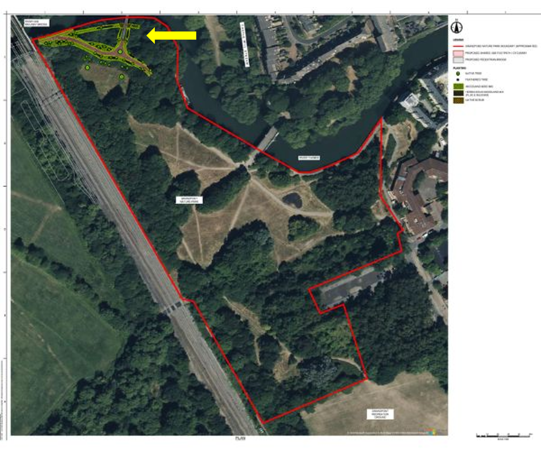
Proposals include widening the path to the west to 3.5m and reducing the steep gradient that exists to make it more accessible. They also include plans to replant trees and understorey vegetation, including introducing a wider range of native trees which will not be affected by the ash dieback affecting some of the existing trees at the park. Once built there will be more trees and vegetation than before and the tree canopy will not be reduced.
In bringing the scheme forward officers have followed the proper process in making the planning application for the bridge
The planning application includes ecological, environmental risk, arboricultural and biodiversity assessments. Public consultation on the proposed development was undertaken before submission of the planning application. The scheme was reviewed before finalisation and submission of the application to the local planning authority.
Options for the bridge's location were explored before the proposed location was put forward as the best location
Enhancements to the existing Gasworks Rail Bridge were looked at in 2016/17. The costings on this proposal were undertaken in 2016. They were not based on achieving current standards and did not take account of the current level of flooding on the meadows. A scheme addressing these issues would be significantly more expensive even before factoring in a sharp increase in the cost of construction since 2016. This option also did not allow for the replacement of the Castle Mill Stream bridge which is only 2m wide and not suitable for increased pedestrian and cycle use. It is not possible to provide a connection on the north side that is wide enough to accommodate pedestrians and cyclists on the existing path. It would therefore require a new flood defended path across the Oxpens Meadows. This route would also be longer and less direct than the proposed bridge. As a result, this was discounted in future option work.
In 2022, alternative landing points for a new bridge were also looked at and the current proposal was the most suitable. This looked at legibility of the crossing, positive user experience, severance of the meadows, amount of footprint in the floodplain, directness of the route to the city centre and the station, amount of structure and impact on trees.
The Growth Deal funds being used to deliver the bridge is an appropriate use of this grant
The bridge is mainly funded by the Oxfordshire Housing and Growth Deal. This included £150m for infrastructure projects across the county supporting the delivery of new homes in councils’ respective local plans. This was to help ensure an “infrastructure first” approach in which investment infrastructure is built before development takes place. The homes attributed to Growth Deal funded schemes in Oxford were done on an area rather than site-specific basis. This project helps improve the transport infrastructure to accommodate additional needs across the city arising from growth.
The Oxpens bridge proposal dates back to 2015 when it was part of a successful funding application by Oxfordshire County Council to the Department for Transport for the project Riverside Routes. It has subsequently been embedded in the Oxford Local Plan. It is subject to consultation and independent review as part of the Local Plan process. The Local Plan identifies the need for enhanced connectivity for walking and cycling and to integrate the site with the city centre.
The proposals have been designed to ensure that the bridge will improve access during the floods, not worsen it
A Flood Risk Assessment (FRA) has been carried out of the bridge proposals to ensure they do not make flooding in the vicinity worse. This FRA has been reviewed by the Environment Agency, which is satisfied there is no added flood risk. The proposed bridge is linked to Oxpens Road by a route that is above flood levels now and with an allowance for greater flooding in the future. The proposed connection at Grandpont is outside the floodplain, and while the towpath under the existing rail bridge floods the route to the east is at very low risk of flooding.
Rate this page


